SORA 2.5 compliance platform · DSAC Guide Ed.3

Build your BVLOS SORA applications in minutes, not weeks.

SkyPath 3D handles the geospatial analysis, containment and ballistics of your mission, then produces a pre-filled authorisation package, ready to file on METEOR, the French authority's portal.

Start for free Open the app User guide (French)

From mission to SORA application: the full SkyPath 3D walkthrough.

The geospatial and paperwork, done for you

Population density to sample, ground risk buffers to size, impact energy to compute, airspace to cross-check, then operational safety objectives to justify. Weeks of work, and a single inconsistency means a rejection.

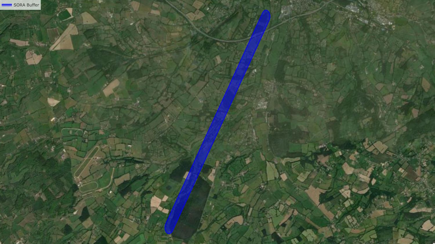
SkyPath runs this analysis in one pass, on official data sources, with traceable calculations, and returns a flight corridor and Ground Risk Buffer ready for the authority.

Flight corridor and Ground Risk Buffer generated by SkyPath 3D

What the engine computes for you

01 · TRAJECTORY

Geospatial routing

Trajectory computed around densely populated areas and regulated airspace, with flight geography and associated volumes.

02 · GROUND

Multi-source analysis

Sampling of population (WorldPop), buildings and roads (OSM) and terrain (SRTM) under your corridor and its adjacent area.

03 · RISK

Containment & ballistics

Ground Risk Buffer sizing, worst-case impact kinetic energy and exclusion volumes, following the DSAC Guide Ed.3 method.

04 · AIR

Classification & airspace

iGRC / GRC, initial and residual ARC, SAIL, and automatic cross-check of the aeronautical zones crossed.

05 · APPLICATION

OSO justifications

Pre-filled operational safety objectives for the SAIL obtained, to review and complete, never to write from scratch.

06 · FILING

METEOR assistance

PDF application, KML, GeoJSON and geofencing files, with a guided assistant for filing on the DSAC portal.

A SORA application for every drone profession

As soon as a mission falls outside the standard scenarios, a SORA risk assessment is required. Since France's national scenarios S-1 to S-3 ended on 1 January 2026, this applies to many professional operations.

AGRICULTURE

Crop spraying and monitoring

Since June 2026, drone spraying has been authorised in France for certain products on slopes of 20 % or more, banana plantations and mother vines, under DSAC authorisation. SkyPath computes the flight volumes and the buffer from inhabited areas.
AERIAL SHOWS

Drone light shows

For a swarm flying near spectators, SkyPath sizes the containment volumes, assesses population density and the adjacent area, and exports the volumes as KML for geofencing.

PHOTOGRAMMETRY

Mapping and 3D surveys

Construction sites, quarries, corridors: draw the area, SkyPath generates the survey pattern and the SORA analysis of the whole surface, including beyond visual line of sight (BVLOS).

RESEARCH

Scientific missions

Environmental campaigns, coastlines, wildlife monitoring, long-range missions in remote areas: a traceable risk assessment, from France to West Africa (ASECNA).

INFRASTRUCTURE INSPECTION

Power lines, railways, pipelines

Long linear BVLOS missions where ground risk changes every kilometre: population, buildings and airspace analysed along the entire route.

CIVIL PROTECTION & HEALTH

Emergency and medical logistics

Fire and rescue services, search and rescue, transport of medical samples or defibrillators: prepare emergency mission authorisations in advance.

An application ready for the authority

Deliverables

What you get

  • Complete SORA application in PDF
  • KML: flight geography, contingency, buffer
  • GeoJSON of volumes and obstacles
  • Geofencing file ready to load
  • Trajectory images and vertical profile
  • METEOR filing assistant
Journey

In three steps

  • Describe the mission: departure, arrival, altitude, drone. Simulate as often as you like, for free.
  • Let the engine compute: maps, density, containment, ballistics and classification, live.
  • Generate the official application: all exports and METEOR assistance unlocked.
Read the full user guide (French) →
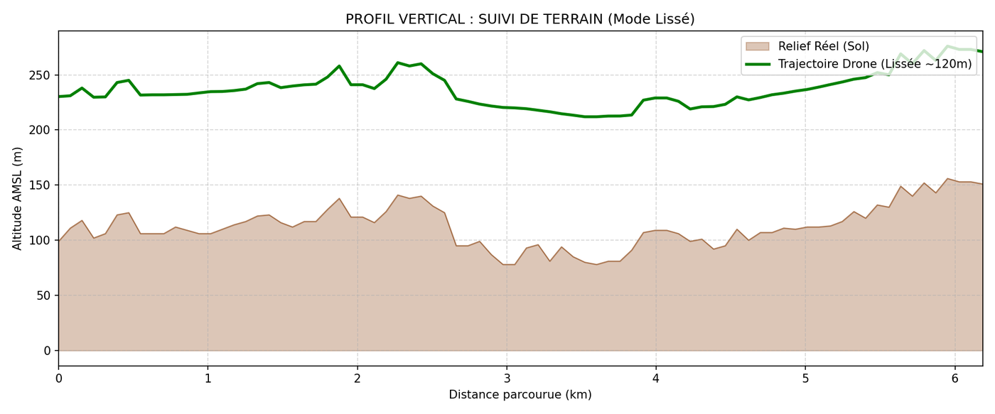
Vertical profile of terrain and drone trajectory

Terrain following and 3D volumes

Terrain is sampled along the whole track to guarantee the real flight height above ground, not a theoretical altitude.

Each volume (flight geography, contingency, Ground Risk Buffer) is computed, sized and documented following the DSAC Guide Ed.3 doctrine.

Rigour & compliance

A compliant foundation, traceable calculations

SkyPath 3D is built on the JARUS SORA 2.5 methodology and the DSAC Guide Ed.3, and on official data sources (WorldPop population, OpenStreetMap buildings and roads, SRTM terrain). Every value (GRC, ARC, SAIL, Ground Risk Buffer, impact energy) is computed and displayed, not guessed.

The tool helps prepare the application; final verification and filing with the authority remain the operator's responsibility. That is why the accuracy and readability of every calculation is our priority.

Prepare for free. Pay for the deliverable.

FREE
€0
  • Unlimited missions & simulations
  • Full analysis and preview
  • No downloads
Create an account
SINGLE APPLICATION
€490
  • One complete official application
  • All exports included
  • METEOR assistance
Choose
STARTER
€99 /month
  • 2 official applications / year included
  • Unlimited simulations
  • 12-month commitment
Choose Starter

Prices in euros. VAT not applicable, art. 293 B of the French Tax Code. Enterprise offer (multi-user, API, support) on request: contact us.

Your next BVLOS mission starts now.

Create a free account, set up your mission and explore the full analysis before generating a single application.

Open SkyPath 3D

Partners & institutional support

Le Perqo Schoolab Fablab Descartes Région Île-de-France Paris Est Sup — Pépite 3EF Desjardins Shawinigan Station F Citizen Entrepreneurs ESIEE Paris